

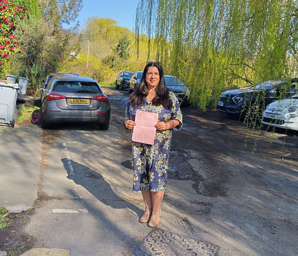
Knutsford Town Council is appealing for users of Moorside to provide evidence of their use to support it being registered as a public right of way.
The Town Council has started the process to register ten new public rights of way across the town. The evidence for the first ‘Definitive Map Modification Order’ application, which applies for the route from Mallard Close to the Tatton Park Dog Wood entrance, has been gathered and an application has been submitted to Cheshire East Council.
The council is now gathering evidence for the next route, Moorside. This is the unadopted section of Moorside, from where the adopted highway ends just past the Moor, through to Dury Lane.
Often, historic public rights of way remain unrecorded despite long standing use by the community, and the need to register a path doesn’t get flagged until there is a threat to access and the council is therefore working proactively to ensure that where evidence supports it, these routes are formally protected for future generations.
Whilst applications are quite straight forward, the process to amend the Definitive Map is detailed and can take several years to complete once submitted to Cheshire East Council.
The Town Council expects to apply to register this route as a ‘Byway Open to All Traffic’, a form of public right of way which covers travel on foot, bicycle and motorised vehicles. Registration will strengthen the Town Council and Cheshire East Council’s powers to ensure the Moorside is passable but would not mean it was maintained to a standard of a typical road. So, the council are inviting evidence from anyone who has used the route on foot or by vehicle.
Applications require the submission of robust evidence demonstrating continuous public use for a period of 20 years, alongside other historic evidence of their existence. The Town Council has identified ten paths which it believes would meet the legal tests and are not currently adopted highways or recorded public rights of way.
The council is inviting residents and members of the public who have used this path over the past 20 years or more (i.e. since 2006 or before) to contact the Town Council on:
01565 653 929
enquiries@knutsfordtowncouncil.gov.uk
...to obtain an evidence form.
Statements, photographs, maps, or any historical documentation relating to the route may assist in supporting the application.
Cllr April Johnson said:
“This part of Moorside is an important right of way in our town centre. It's a well used route and borders on the RAMSAR and SSSI site of the Moor Pool.
This DMMO application is about protecting a historic route that has been used by local people for generations. It's not about creating a new path, but ensuring that a long-established public right of way is properly recognised and safeguarded for future generations.
Moorside has long been an important route within our community. Securing its status through a Definitive Map Modification Order would help preserve an important piece of Knutsford's heritage while ensuring residents can continue to enjoy safe and lawful access.”
The full list of routes the council plans to prepare evidence for is at available at:
 Man jailed following burglaries in Congleton and Sandbach
 Knutsford Town Mayor invites community to Civic Parade
 Police deliver training to bus companies to help spot signs of child exploitation
 Food waste caddies make their way to residents
 Don’t lose your vote! Residents urged to check their voter registration details
 Man jailed for drug dealing in Middlewich
 Man charged with exposure offences in Macclesfield
 Beech Hall School Honoured as ‘Winner’ in Prestigious National School Awards
 Prolific Northwich offender jailed
 Getting Congleton Bloom Ready
 Man jailed for stalking his ex-girlfriend with fake Tinder profile
 Free summer sessions now open for the Holiday Activities and Food Programme
 New ‘showstopper’ coming to Macclesfield park this summer
 Cheshire East Council launches Community Voices panel
 Cheshire East Council to host recruitment open day for waste and recycling roles
 Say NO MORE to domestic abuse during the World Cup
 Armed Forces flag raising events held across Cheshire East
 Northwich drug dealer jailed


Comments
Add a comment